French Polynesia
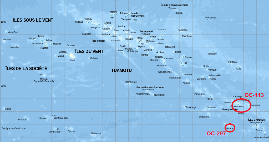
TX0A Acteon Group (OC-113)
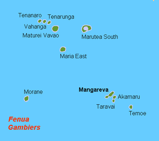
TX0M Morane Group (OC-297)
|
THE PROJECT
The DXCC of French Polynesia.
The atolls of Maria Est and Morane are uninhabited, and there is no boat transportation to them commonly available in Mangareva. Worth noting, the skipper agreed to bring his yacht to Mangareva specifically for this project, which involves rather complex logistics. The coral reef of both Maria Est and Morane atolls offer no entrance into the lagoon, which are fully enclosed and hypersaline. To say that landing on and departing from these atolls will be challenging is an understatement. However, once we manage to cross the reef (fingers crossed!), moving all the equipment to and from one of the sandbanks will be equally difficult. In order to mitigate the hazards and increase safety, the skipper will bring on his yacht two inflatable dinghies. One of them will remain with the operating team at all times during their stay on each atoll.
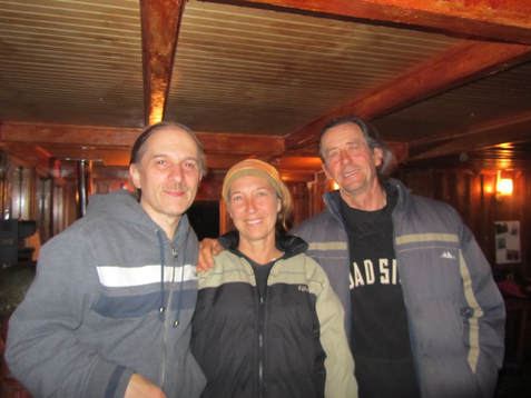
With skipper Jean-Yves (right) and his wife Sandrine (center) at the southernmost bar
in the world, run by Micalvi Yacht Club (Navarino Island, Jan 2011). The plan is to operate from each atoll for 5 full days. The typical dominant wind for that period of the year tends to blow from the east, in which case the first stop will be Morane, followed by Maria Est. If so, the tentative schedule is to operate from Morane between December 6 to 10 (based on the UTC time), and from Maria Est between December 12 to 16. Nevertheless, the wind can also blow from the southeast or northeast, which can change the above tentative plan. Consequently, the final decision regarding the sailing itinerary will be made at the time of leaving Mangareva, based on the weather forecast.
On each island, the operating team will communicate with the crew on the yacht via VHF radio. The chasers will be able to track our progress via the InReach system. The tracking link will be made available between December 2 and 19. The inReach system will also allow us to exchange information with Johan (PA3EXX), our Pilot Station. He will keep the community informed on our progress, and provide us with appropriate feedback. The team must return to Mangareva by no later than the morning of December 18, in order for Cezar and Adrian to catch their flight to Papeete, from where they will fly first to San Francisco, and then to Toronto and New York City, respectively. They should be back home before midnight on December 19. This is a complex and extremely expensive project, and we need your support to defray some of the considerable costs incurred! All donors will be acknowledged timely on this website. |
SPONSORS & DONORS
Thank you for your support! 


The stations listed below offered support prior to the start of this DX expedition:
4X4-2238 5B4AHJ 7K3EOP 9A2AA AA5AT AB5EU AD1C CT4NH DG2AT DJ3XG DK1FW DK7TX DL1BKI DL1BKK DL3ZZ DL4FCS DL4KQ DL5AXX DL5ME DL5MX DL6DQW DL6KVA DL6MKA DL6MST DL8USA DO4DXA DS4DRE E72U E73Y EA8AKN F-59706 F4FET F4WBN F6BFH F8AMV G3YBO G3ZAY G4VMX GI3OQR HB9BZA HS0ZIV I2YDX I4EAT I4MKN I6COJ IK4DRY IK4WMA IT9DAA IZ2AMW JA1BPA JA1EY JA1SKE JA2AYP JA2IHL JA3UCO JA4GXS JA5IU JA6EXO JA6FIO JA7BWT JA7DOT JA7MGP JA8COE JA8MS JA8RJE JA9GPG JA9IFF JE1DXC JE2VFX JE3GUG JE7JIS JF1SEK JF4VZT JG1UKW JH2IEE JH2RMU JH2XQY JH3GFA JH4DYP JH7VHZ JI3DST JI3MJK JJ0NCC JK1KSB JK1TCV JM1PXG JM2LEI JN3SAC JN6RZM JO1CRA JP7EIP JR1WCT K0AP K1NU K1OA K5MT K6RNK K9RR KA1R KD1CT KJ3L KM4HI LA8DW N2AJ N4II N4WW N5ET N5UR N6AWD N6FX N6JV N6VR N9EAJ OE1HHB OE2VEL OE3EVA OE3GCU OE3RPB OE3SGA OE3WWB OE6IMD OH2BCK OH2FT OK1TN ON4CD ON4IZ OZ1HPS PT7WA PY7ZZ R9OK RA6AR RJ3AA RZ3EC S57L S58N SM3DMP SM3EVR SM5LNE SM6CVX SM7DXQ SP5APW UA0CID UA0FO UA0ZC UA1OIZ UA1OLM UA3AGW UA4CR VE3JV VE3VHB VE3ZZ VE7DP VE7JH VE7QCR VK3GA VK3QI VK5CE VK5MAV VK7BC VK8NSB W1JR W1NG W4DKS W4FOA W4PID W5BOS W5GAI W5PF W5WP W7BEM W9OO WB2YQH WC6DX WD8PKF YT7DX |